Flood Resiliency
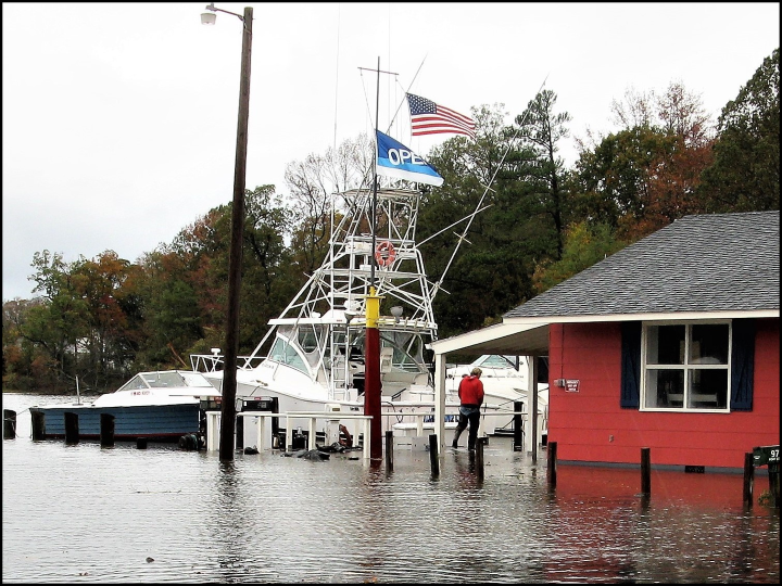
Living in Talbot County's beautiful and fragile environment exposes residents and visitors to flood hazards and sea-level rise. Being informed about current and future flood risks allows you to make informed decisions to prepare for rising waters.
The following guides provide flood hazard information and access to online resources:
- The Basics of Flood Safety
- Understanding NFIP Community Rating System
- Build Responsibly: Understanding Talbot County's Floodplain Management Ordinance
- Elevation Certificate vs. Certificate of Elevation Compliance Guide
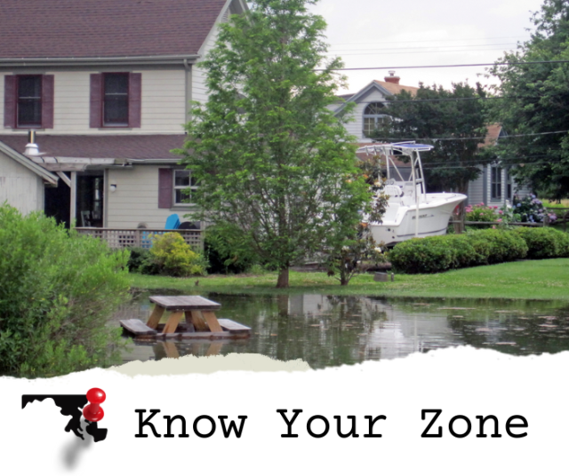
Know Your Zone
To find your community's flood map, use Talbot County's Interactive Map. Search using your address, and apply the "FEMA Flood Zones 2016" map layer.
High-risk flood areas begin with the letters A or V on FEMA flood maps.
Search Talbot Flood MapsProgram Coodinator
Bryce Yelton
Planning and Zoning
215 Bay Street, Suite 2
Easton, MD 21601
410-770-8030
Byelton@Talbotcountymd.gov
Frequently Asked Questions
-
Is Talbot County subject to flooding?
Talbot County has experienced many hurricanes and other severe storms throughout our history. In addition to storm surge related flooding, Talbot County also experiencing seasonal flooding periods of heavy rain.
-
What is a flood map?
Flood maps show a community’s risk of flooding. Specifically, flood maps show a community’s flood zone, floodplain boundaries, and base flood elevation.
Property owners, insurance agents, and lenders can use flood maps to determine flood insurance requirements and policy costs.
Because your flood risk changes over time, the National Flood Insurance Program (NFIP) and the Federal Emergency Management Agency (FEMA) work with communities across the country to identify and map flood risk on an ongoing basis.
-
How can I determine if my property is in a Special Flood Hazard Area?
To find your community's flood map, use Talbot County's Interactive Map. Search using your address, and apply the "FEMA Flood Zones 2016" Layer.
You can also use FEMA's Flood Map Service Center tool, or reach out to the Floodplain Coordinator for assistance.
-
What does my flood zone mean?
Everyone lives in an area with some flood risk—it’s just a question of whether you live in a high-risk, low-risk, or moderate-risk flood area.
Flood zones are indicated in a community’s flood map. Each flood zone describes the flood risk for a particular area, and those flood zones are used to determine insurance requirements and costs.
Know your property’s flood risk
To find your community's flood map, use Talbot County's Interactive Map. Search using your address, and apply the "FEMA Flood Zones 2016" Layer.
Moderate- to low-risk flood areas are designated with the letters B, C, and X on FEMA flood maps. In these areas, the risk of being flooded is reduced, but not completely removed. One in three insurance claims come from moderate- to low-risk flood areas.
High-risk flood areas begin with the letters A or V on FEMA flood maps. These areas face the highest risk of flooding. If you own a property in a high-risk zone and have a federally backed mortgage, you are required to purchase flood insurance as a condition of that loan.
-
Do I need flood insurance and do I have enough flood insurance?
Flood Insurance is a requirement if your home or building is within a special flood hazard area. It is also a good idea to have flood insurance if your home or building is near a special flood hazard area.
Standard homeowner’s insurance policies do not cover flood damage, a separate insurance policy just for flood waters is needed. For flood policy information, contact your local flood insurance agent or go to floodsmart.gov. Generally, there is a 30-day waiting period for a flood insurance policy to become activated.
-
What regulations apply to construction activities within a flood zone?
The Talbot County Floodplain Management Ordinance mandates that certain procedures be followed for construction-related work within properties designated as flood zones on the Talbot Flood Insurance Rate Maps. Copies of this ordinance are also available from Planning and Zoning upon request.
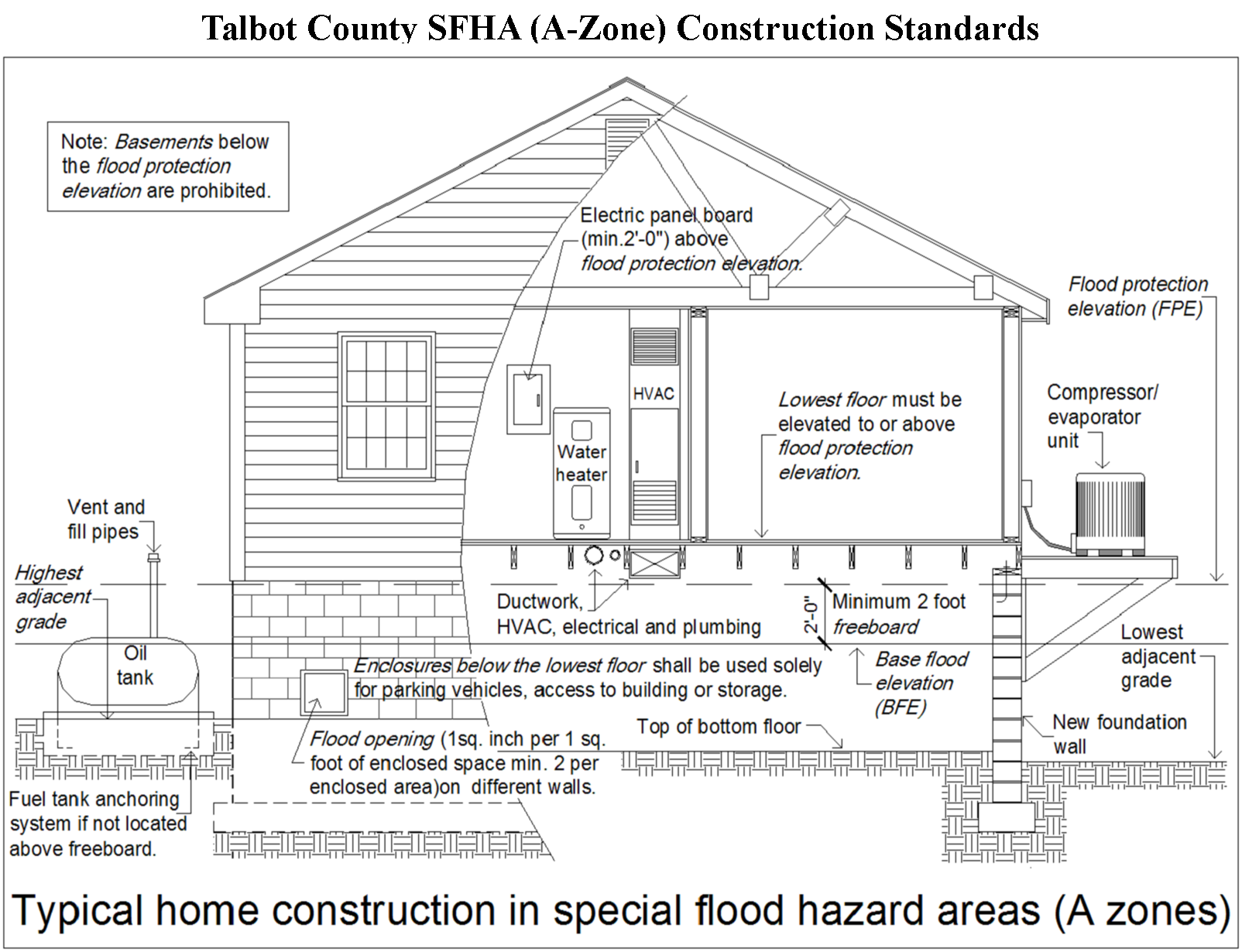
Typical Construction Standards in special flood hazard areas (A zone)
Additional Tips and Guidelines
- All construction within the regulatory flood zone requires a permit.
- All new construction or substantial improvements within the special flood hazard areas shall comply with the standards set forth in the Talbot County Floodplain Ordinance as well as any other applicable codes and ordinances.
- All proposed new structures or substantial improvement of existing structures in a flood zone must be constructed at least two (2.0) feet above the Base Flood Elevation or 7.0 feet NAVD whichever is higher. Enclosed areas not elevated in these structures can only be used for parking, limited storage, and access to the building, must be constructed from flood-damage-resistant materials and must have flood openings that meet certain criteria.
- A crawlspace or garage must be vented to allow one square inch of effective flow area for every one square foot of the area below flood elevation and must automatically allow movement of water in and out. The bottom of the vents must be no more than 1-foot above grade. Flood Vents must meet all requirements in FEMA Technical Bulletin 1 Openings in Foundation Walls and Walls of Enclosures (March 2020 Update).
- We require for new construction and substantial improvements two elevation certificates. One Upon placement of the lowest floor and prior to further vertical construction; and another prior to the final inspection “as built”. An Agreement to Submit Elevation Certificate document is required before approval of permits requiring elevation certificates. The Elevation Certificate form must be completed by a Maryland licensed land surveyor or registered civil engineer. An Elevation Certificate is necessary before you can receive a Certificate of Occupancy.
- The Elevation Certificate is required by the National Flood Insurance Program to determine flood insurance rates for the structure. It also provides documentation that our community is enforcing its building and floodplain ordinances.
This is not an exhaustive list of the requirements of the floodplain ordinance. If you have any project specific questions, please contact the Floodplain Coordinator.
For information on how to apply for a permit please click here.
-
Where do I get a "Flood Elevation Certificate"?
FEMA Elevation Certificates are important documents that certify your building’s elevation above mean sea level. If you live in a Special Flood Hazard Area, you should provide an Elevation Certificate to your insurance agent for the best rate on flood insurance and to ensure that your premium accurately reflects your risk. Obtaining an Elevation Certificate also can help you make decisions about mitigation before a flood event and rebuilding after a disaster strikes.
Comparing Your Building’s Elevation to a Potential Base Flood Elevation
Your insurance agent will use the Elevation Certificate to compare your building’s lowest floor elevation to the Base Flood Elevation (BFE). This is a flood event with a 1 percent chance of equaling or exceeding the BFE in any given year. The BFE identifies how high the water is likely to rise in a base flood event. The land area of the base flood is known as the Special Flood Hazard Area, floodplain or high-risk flood zone.
Finding Your Building’s Elevation
When a home is purchased within a Special Flood Hazard Area (SFHA), an Elevation Certificate may or may not transfer with the property's sale or otherwise be unavailable. Talbot County as part of its Floodplain Management Ordinance requires an Elevation Certificate for new and other construction activities within the SFHA. This elevation information may be on file in the Permits and Inspections Department.
To check the availability of an Elevation Certificate for your building:
You may also contact the Talbot County Floodplain Management Coordinator (410) 770-8030 to determine if an Elevation Certificate is on file for your home.
To have your SFHA located home or business structure's elevation certified, contact a Maryland State licensed surveyor, architect or engineer to complete an Elevation Certificate for your building.
-
What is the Community Rating System, and how does it work?
The Community Rating System (CRS) is a voluntary incentive program that recognizes and rewards community floodplain management that exceeds minimum requirements set forth by the NFIP. Talbot County has participated in the program since 2014.
The CRS has three goals:
- Reduce flood damage to insurable property.
- Strengthen and support the insurance aspects of the National Flood
Insurance Program. - Encourage a comprehensive approach to floodplain management.
Currently, Talbot County is rated as a Class 7 community. This means that properties located in the Special Flood Hazard Area (SFHA), and within the un-incorporated locales of the county, are eligible for a 15% discount on flood insurance premiums. Properties that are not located in the SFHA are eligible for 5% rate discount on a Preferred Risk Policy.
In addition to discounts on flood insurance, other benefits of CRS participation include:
- Citizens and property owners have increased opportunities to learn about risk, evaluate their individual vulnerabilities, and take action to protect themselves, their homes and businesses.
- CRS floodplain management activities provide more public safety, reduce damage to property and public infrastructure and avoid/reduce economic disruption and loss after a flood.
- Communities can evaluate the effectiveness of their flood programs against a nationally recognized benchmark.
-
How can I protect my property from flood-related damages?
The Federal Emergency Management Agency maintains an electronic library of reference materials on topics such as retrofitting structures for enhanced flood and hurricane resistance and protecting building utilities from flood damages.
Top Resources
- Answers to Questions about the National Flood Insurance Program, F-084 (2011)
- Coastal Construction Manual, FEMA P-55 (2011)
- Protecting Building Utilities from Flood Damage, FEMA P-348 (1999)
Talbot County Free Library has multiple publications available in their reference sections on protecting property from flood damages.
Additional Resources
Weather and Tide Forecasts
National Weather Service: Local weather forecasts including hazardous weather alerts
National Hurricane Center: Tropical Storm and hurricane weather tracking
NOAA - Talbot County Tide Predictions Map: Click on a tide station symbol for current and predicted tide levels, use date ranges within each station's linked web page to customize water level predications, view a graphic of each station's tide frequency (tide height, time at lowest or highest tide) and print tide information
Talbot County Tidal Surge Maps
Claiborne, MD NOAA Live Tide Guage
Cambridge, MD NOAA Live Tide Guage
Talbot County Resiliency
Flood Insurance Study: Effective July 20, 2016, the Talbot County Council adopted a new Flood Insurance Study (FIS) and Flood Insurance Rate Maps (FIRMS). The FIS and FIRMs were updated by the Federal Emergency Management Agency as part of a National Flood Insurance Program conversion to digital or DFIRM maps. Talbot County legislative Bill 1325 adopted the updated FIS and FIRMs.
2022 Hazard Mitigation & Community Resilience Plan
Determining Risk
FEMA Flood Map Service Center - The FEMA Flood Map Service Center (MSC) is the official public source for flood hazard information produced in support of the National Flood Insurance Program (NFIP). Use the MSC to find your official flood map that includes local map amendments and revisions
DFIRM Outreach Program - This site is designed to guide homeowners/renters as well as communities through the process of determining their current flood risk as well as future flood risk based on the preliminary Digital Flood Insurance Rate Maps (DFIRMs)
Before, During, and After a Flood
MyCoast: Maryland: Communicate flooding and storm damage in your community. The system collects and analyze photos which are linked to precipitation, riverine, and tidal data to create reports that help government agencies, business owners, and residents understand impacts in your community and encourage action to reduce localized flooding
Flood Smart - The official site of the National Flood Insurance Program, managed by FEMA
Ready.gov - Provides helpful information on what to do before, during and after a flood event
Talbot County Md DES Mobile Application: Receive "local" emergency and flood alerts, weather events, social media, contacts and preparedness guidance.
Citizen Alert System: Receive emergency alerts and other important community news
Plan and Prepare for Natural Disasters
Asbestos and Natural Disasters Guide & Mesolthelioma Symptoms
For inquiries related to flood zones, FEMA flood maps, or hazard mitigation, please contact the Floodplain Management Coordinator at Byelton@Talbotcountymd.gov.
Page last modified Monday, October 7, 2024 12:26:40 PM